
Gentlemen, that reminds me......
FAQ (Frequently Asked Questions)
RAF Bawdsey
"What did you do in the "Cold War" Dad?"
Part 2 - Master Radar Station
|
"Happy are those who work
for peace; God will call them his children!" |
 I joined the Royal Air Force in 1970 and trained as an apprentice ground radar fitter at the No.1 Radio School,
RAF Locking near Weston-Super-Mare in Avon. I completed my RAF apprenticeship in 1972 and I was posted to RAF Bawdsey near Felixstowe in Suffolk, England. The first radar I worked on was this Type 80 radar in the black and white photograph to the right. This radar was developed in the early 1950's under the project code name of "Green Garlic", Almost overnight
this radar made the "Rotor" air defence system radars redundant, offering superior range and performance over existing "Rotor" equipment that formed a chain of air defence radar stations that covered the United Kingdom. The Type 80 was so successful that many of the old "Rotor" stations closed within a few years of commencing operation
and the stations equipped with the Type 80 became Master Radar Stations (MRS). There were also two or three U.S. built AN/FPS-6 height finding radars at Bawdsey and the tower for a Type 54 "Chain Home Extra Low" (CHEL) radar. In my
days at Bawdsey (1972-1974) the Type 54 head had been removed and a reflector for a microwave link was attached to the tower. The microwave link brought live radar feed from the Type 84 or Type 85 radar's at RAF Neatishead, up the coast
in Norfolk. Some of the equipment (the AN/FPS-6 and the IFF Mk 10 transceivers) came over from the USA, possibly under "Lease Lend" or the "Marshall Plan", and carried crossed Union Jack and Stars and Stripes flags with the motto "Hands linked across the water in peace" or something similar.
I joined the Royal Air Force in 1970 and trained as an apprentice ground radar fitter at the No.1 Radio School,
RAF Locking near Weston-Super-Mare in Avon. I completed my RAF apprenticeship in 1972 and I was posted to RAF Bawdsey near Felixstowe in Suffolk, England. The first radar I worked on was this Type 80 radar in the black and white photograph to the right. This radar was developed in the early 1950's under the project code name of "Green Garlic", Almost overnight
this radar made the "Rotor" air defence system radars redundant, offering superior range and performance over existing "Rotor" equipment that formed a chain of air defence radar stations that covered the United Kingdom. The Type 80 was so successful that many of the old "Rotor" stations closed within a few years of commencing operation
and the stations equipped with the Type 80 became Master Radar Stations (MRS). There were also two or three U.S. built AN/FPS-6 height finding radars at Bawdsey and the tower for a Type 54 "Chain Home Extra Low" (CHEL) radar. In my
days at Bawdsey (1972-1974) the Type 54 head had been removed and a reflector for a microwave link was attached to the tower. The microwave link brought live radar feed from the Type 84 or Type 85 radar's at RAF Neatishead, up the coast
in Norfolk. Some of the equipment (the AN/FPS-6 and the IFF Mk 10 transceivers) came over from the USA, possibly under "Lease Lend" or the "Marshall Plan", and carried crossed Union Jack and Stars and Stripes flags with the motto "Hands linked across the water in peace" or something similar.
 The Quilter motto, displayed over the entrance to Bawdsey Manor, was "Plutot Mourir Que Changer" (Rather die than change). This seemed to be an inappropriate motto for the station where Robert Watson-Watt developed his ideas for using Radar as an air
defence tool; I prefered the R.A.F. Bawdsey motto of "First in the field". The "Chain Home" air defence system that gave Great Britain the decisive edge in the Battle of Britain during World War II was developed here and the site later formed a part of the "Rotor" air defence system. The concrete plinths that the Chain Home antennae stood on were
still in place in the 1970's, as was one of the transmitter towers, pictured here.
The Quilter motto, displayed over the entrance to Bawdsey Manor, was "Plutot Mourir Que Changer" (Rather die than change). This seemed to be an inappropriate motto for the station where Robert Watson-Watt developed his ideas for using Radar as an air
defence tool; I prefered the R.A.F. Bawdsey motto of "First in the field". The "Chain Home" air defence system that gave Great Britain the decisive edge in the Battle of Britain during World War II was developed here and the site later formed a part of the "Rotor" air defence system. The concrete plinths that the Chain Home antennae stood on were
still in place in the 1970's, as was one of the transmitter towers, pictured here.
Fighter control operations were conducted from the underground "R3" bunker that had originally formed a part of the "Rotor" air defence system. The "R3" was always called "The Hole" or "The R3" by us insiders in my day (1970's), we never used the term "bunker". At Bawdsey the "R3" was located a few hundred yards North of the Chain Home tower on the "Tech" or "A" site.
 It's been some 28 years since I last went "down The Hole" and the memory fades somewhat but I'll try and give you a quick tour of the R3 at R.A.F. Bawdsey as I recall it in 1974. The entrance to the R3 was through a guard room identical to the
one at Anstruther shown here. I've lost count of the number of times I've heard or seen the guard room described as "Looking just like an ordinary farm house"! To me it doesn't and I'm sure the Russians weren't fooled either; several acres of rotating and nodding antennae and an RF spectrum powerful enough to cook your lunch must have been a dead give away! On entering the guard room there was a security cage where we handed over our ID cards, in return we received a laminated pass with a clip
to attach it to your clothing. The pass had to be on display at all times and was your authority to be in the Hole. Our ID cards were retained on the surface in the guard room, if we had to evacuate the Hole (fire etc.) the ID cards could be used to find out how many people were still trapped inside.
It's been some 28 years since I last went "down The Hole" and the memory fades somewhat but I'll try and give you a quick tour of the R3 at R.A.F. Bawdsey as I recall it in 1974. The entrance to the R3 was through a guard room identical to the
one at Anstruther shown here. I've lost count of the number of times I've heard or seen the guard room described as "Looking just like an ordinary farm house"! To me it doesn't and I'm sure the Russians weren't fooled either; several acres of rotating and nodding antennae and an RF spectrum powerful enough to cook your lunch must have been a dead give away! On entering the guard room there was a security cage where we handed over our ID cards, in return we received a laminated pass with a clip
to attach it to your clothing. The pass had to be on display at all times and was your authority to be in the Hole. Our ID cards were retained on the surface in the guard room, if we had to evacuate the Hole (fire etc.) the ID cards could be used to find out how many people were still trapped inside.
Once through the cage there was a door leading to a stair well and also a short corridor leading to the "Comcen" or Communications Centre located at the opposite end of the building. The Comcen comprised of several teleprinters (Creed 7b rings a bell - if you'll pardon the pun) and was the work place of the lass with the red hair who became my wife, LACW Sandra (Sandy) Strachan, who was a TPO (Teleprinter Operator). The GPO (later to become British Telecom) engineers had a room on the right of the corridor that was used as a rest room I believe.
 We descended some stairs in the stair well and proceeded along a long tunnel like the one shown here. The tunnel ended at a blast door (which was usually kept dogged open) and passing through the blast doors brought you to the upper floor corridor of the two
floor R3. On the right was a small room containing a manual PBX (Private Branch Exchange) telephone switchboard where the telephone operator worked and a flight of stairs leading to the floor below. On the left was the "Control Room", dominated by a large Perspex plotting map table set in a pit. The map had the radar image projected on it from the PDU (see below) located on the floor below. Various displays were arranged around the pit, one I recall was manned by the "Display Controller",
this operator reported faults to the techs at "Faults Control" downstairs in the "Radar Office".
We descended some stairs in the stair well and proceeded along a long tunnel like the one shown here. The tunnel ended at a blast door (which was usually kept dogged open) and passing through the blast doors brought you to the upper floor corridor of the two
floor R3. On the right was a small room containing a manual PBX (Private Branch Exchange) telephone switchboard where the telephone operator worked and a flight of stairs leading to the floor below. On the left was the "Control Room", dominated by a large Perspex plotting map table set in a pit. The map had the radar image projected on it from the PDU (see below) located on the floor below. Various displays were arranged around the pit, one I recall was manned by the "Display Controller",
this operator reported faults to the techs at "Faults Control" downstairs in the "Radar Office".
Just along the corridor past the control room, on the left hand side, was the "Heights" cabin. The "Heights" consoles displayed the radar picture from the AN/FPS-6 height finder radars. The 12 inch Range Height Indicator (RHI) display showed range against height on a CRT. The required target was marked on the RHI display by a strobe marker that was initiated from a PPI operator's console. Initiating this strobe caused the height finder radar to swing around to face the target azimuth (this movement was called azication) The height operator aligned his cursor to the centre of the indicated radar paint on his height display and the height was then calculated by equipment in the Radar Office on the lower floor. The calculated height was then displayed on an indicator adjacent to the PPI operator console requesting the height. As you proceed along the corridor you passed, on the left, the Mullard Trainer "Sims" cabin where simulated targets could be generated and overlaid on the regular radar picture for training purposes, several fighter control cabins similar to the one shown below and offices on the left hand side, whilst on the right hand side of the corridor were more offices, toilets, canteen facilities and a small room housing the MARS (Multiple Automatic Recording System) equipment. The MARS equipment consisted of several large 1/2 inch reel to reel tape recorders that recorded all the site's radio traffic to and from the aircraft. Occasionally there would be an incident such as an aircraft accident or an air miss and we would be ordered to secure the relevant tapes until an enquiry could be held. The tape would then have to be transcribed on to paper, so at some point one of the tech's would load the tape up and play it back to a team of "Scopie's" (see below) to write down. A typical arrangement for these transcriptions was an officer, an NCO and an airman/airwoman from the Scopie's plus the tech. I held a Private Pilot Licence at the time, so having an ear for "aero-speak" I would help out with the transcription. There was an air of sadness amongst the Scopie's if there had been an incident involving loss of life and I recall formations of Phantom F4 fighters making memorial flights over the site on several occasions with a gap in the formation for the missing crew
 The scene shown here was typical of a fighter control cabin. The display that the officer is using appears to be a "Console type 64", to right and left of the display are "key and lamp" boards that enabled the controller to select radio and telephone channels,
whilst to the right of the lady's head is the switch box for selecting IFF (Identification, Friend or Foe) codes. The box above the circular radar screen that the controller is writing on appears to be the height display mentioned above. The map on the wall shows the Midlands, East Anglia, the South and South East of England. This photograph has been "staged"; these cabins were usually very dimly lit.
The scene shown here was typical of a fighter control cabin. The display that the officer is using appears to be a "Console type 64", to right and left of the display are "key and lamp" boards that enabled the controller to select radio and telephone channels,
whilst to the right of the lady's head is the switch box for selecting IFF (Identification, Friend or Foe) codes. The box above the circular radar screen that the controller is writing on appears to be the height display mentioned above. The map on the wall shows the Midlands, East Anglia, the South and South East of England. This photograph has been "staged"; these cabins were usually very dimly lit.
At the far end of the upper corridor was the emergency exit and stairway leading up to the surface and a stair leading down to the lower floor. After descending these stairs we emerge on the lower floor. We are now proceeding in the opposite direction, on the right is "Eng. Co-ord" - the technical offices. On the left are the Power and Plant rooms, continuously manned by Department of Environment personnel. Further along on the right is the radar workshop, with benches and test equipment for carrying out repairs and adjustments - here I spent many miserable hours adjusting piles of carpenter relays. Through the workshop was the "Radar Office", here were the racks of equipment that calculated the target heights, generated the maps that appeared on the consoles, the "Fixed Coil" equipment generating the wave forms that produced the displays, the IFF equipment and some of the equipment for the microwave link from RAF Neatishead that carried radar video from their Type 84 or Type 85 radars to be displayed on Bawdsey's consoles. "Faults Control" was located in the Radar Office, this consisted of two Console type 64 radar displays, IFF facilities and a key and lamp switch board for telephone communications. The "Display Controller" passed the faults to "Faults Control", who would then put a technician to work on the fault. The Faults Control displays could be set up to monitor the local Type 80 radar and the Type 84 or Type 85 display from RAF Neatishead, up the coast in Norfolk. Past the work shop, on the right, there was a room housing some of the AN/FPS-6 height finder radar equipment and further on again was the Kelvin Hughes PDU (Photographic Development Unit). At the end of the corridor was the GPO Frame Room housing the telephone equipment and a set of stairs leading back to the upper corridor, coming up adjacent to the manual PBX room mentioned above.
 The PDU consisted of equipment that could record the radar image on 35 mm film, develop, fix and dry the image and then project it up on to the plotting table in the control room on the floor above. The displayed image was one minute behind real time. The PPI image from a high intensity CRT was projected on to the
film through a focusing lens. Each revolution of the radar antenna took 15 seconds, so it took this time to expose the film to a full revolution. At the end of the sweep the frame would be moved on to be developed, whilst the next frame was exposed. When the frame moved on at the end of the next sweep the image was fixed, it then moved on again and it was dried. Finally the frame moved on once more where it was projected, via a mirror, to the floor above. Mean while the next frame to be exposed has been following
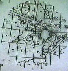
on through the process, so at the end of the next revolution this frame was projected, 15 seconds after its predecessor. As frame after frame was displayed on the map the plotters in the pit could place markers on the map to indicate friendly or hostile returns. The senior officers could rapidly judge how a threat was building and see the big picture by watching the display on the map. The photograph shows the image at R.A.F. Sopley in southern England. The centre of the display usually consists of permanent
echoes, or "clutter", and has been "blanked off" here (clear circular area, right of centre). Principle airways are represented by the long straight parallel lines. The squares with letters in them are used to make up the "Geo-Ref", used to convey the position of a target by voice over telephone lines. Individual aircraft appear as small black dots. The maximum range shown here is around 450 Km or around 260 miles. Occasionally there would be an incident
such as an aircraft accident or an air miss and like the MARS described tapes above, we would be ordered to secure the relevant film until an enquiry could be held.
The PDU consisted of equipment that could record the radar image on 35 mm film, develop, fix and dry the image and then project it up on to the plotting table in the control room on the floor above. The displayed image was one minute behind real time. The PPI image from a high intensity CRT was projected on to the
film through a focusing lens. Each revolution of the radar antenna took 15 seconds, so it took this time to expose the film to a full revolution. At the end of the sweep the frame would be moved on to be developed, whilst the next frame was exposed. When the frame moved on at the end of the next sweep the image was fixed, it then moved on again and it was dried. Finally the frame moved on once more where it was projected, via a mirror, to the floor above. Mean while the next frame to be exposed has been following
on through the process, so at the end of the next revolution this frame was projected, 15 seconds after its predecessor. As frame after frame was displayed on the map the plotters in the pit could place markers on the map to indicate friendly or hostile returns. The senior officers could rapidly judge how a threat was building and see the big picture by watching the display on the map. The photograph shows the image at R.A.F. Sopley in southern England. The centre of the display usually consists of permanent
echoes, or "clutter", and has been "blanked off" here (clear circular area, right of centre). Principle airways are represented by the long straight parallel lines. The squares with letters in them are used to make up the "Geo-Ref", used to convey the position of a target by voice over telephone lines. Individual aircraft appear as small black dots. The maximum range shown here is around 450 Km or around 260 miles. Occasionally there would be an incident
such as an aircraft accident or an air miss and like the MARS described tapes above, we would be ordered to secure the relevant film until an enquiry could be held.
During my service there Bawdsey was used to train the Fighter Controllers and the Aerospace Systems Operators - otherwise known to the rest of the radar world as "Scope Dopes" or "Scopie's". The ASSOp's were taught, amongst other things, the rare skill of backwards writing so that they could stand behind the edge lit, clear perspex tote boards in the Fighter Control cabins mentioned above and mark them up the with information such as airfield states, aircraft availability, weather and so on. A large proportion of the trainees were women and this might help to explain the unofficial names for the place; "The Marriage Bureau" or "The Baby Farm", though I suspect many RAF stations could lay claim to the designation.
If you are interested in the story of RAF Bawdsey and early British radar development then I can highly recommend Gordon Kinsey's book "Bawdsey - Birth Of The Beam" published by Terence Dalton Limited, Lavenham, Suffolk, 1983 ISBN 0 86138 017 7. The book contains many anecdotal accounts and photographs of Bawdsey.


